Physical Geography
TEKS Alignment - §113.43. World Geography Studies (One Credit), Beginning 2011-2012.
(3) Geography. The student understands how physical processes shape patterns in the physical environment. The student is expected to:
(B) describe the physical processes that affect the environments of regions, including weather, tectonic forces, erosion, and soil-building processes;
(4) Geography. The student understands the patterns and characteristics of major landforms, climates, and ecosystems of Earth and the interrelated processes that produce them. The student is expected to:
(A) explain how elevation, latitude, wind systems, ocean currents, position on a continent, and mountain barriers influence temperature, precipitation, and distribution of climate regions;
(B) describe different landforms and the physical processes that cause their development;
| Key Vocabulary | Key Places |
|---|---|
|
alluvial |
Mount Merapi |
Once you have reviewed the module summary, TEKS alignment goals, and key terms and definitions, use the menu navigation to access all module resources.
Overview
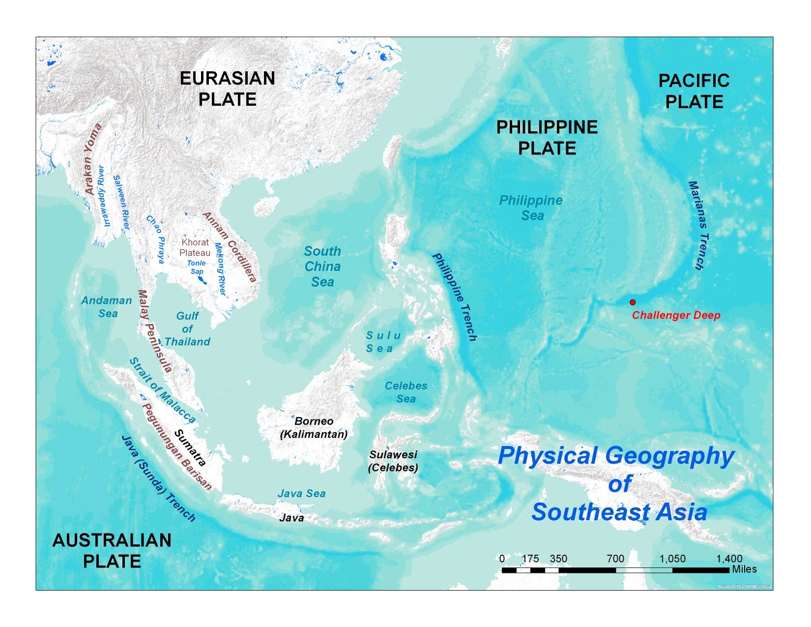
Southeast Asia is a land of collisions – both cultural and physical. Straddling the boundaries of four separate tectonic plates, this region is constantly reshaping itself – shifting, colliding, and often erupting. From the deepest spot on the ocean floor to some of the most active volcanoes in the world, this is a region of extremes. The region has more volcanoes than any world region except East Asia. In fact, East and Southeast Asia together contain around 1/3 of all the world’s volcanoes.
It is also a region of divisions – both cultural and physical, as well. Part of the region lies on a series of peninsulas jutting out from the Asian continent. The remaining part of the region is spread out across a vast expanse of islands. Thousands upon thousands of islands spread out across an area larger than the contiguous United States.
The resources in this module will assist you in helping your students understand the vast complexity of this region’s physical geography. The video presentations discuss various features and phenomena that impact the physical geography. These videos can be used when preparing a unit on Southeast Asia, as well as in the classroom with students. The case study focuses upon the recent (2010) eruption of Mount Merapi in Indonesia. It includes a power point with information on the cause and effects of this eruption and includes a link to an online photo essay of the eruption provided by The Boston Globe. The case study also includes a Google Earth kml file with thermal and sulfur dioxide emission images and satellite images of the eruption. The lesson plan is a brief introduction to the major physical features of this region where students create annotated sketch maps.